![[UK map]](/img/locationmap.png)
| OSGB36 trig archive spreadsheet - IW | |||||||||||||
|---|---|---|---|---|---|---|---|---|---|---|---|---|---|
| Trig Name | Original Name | New Name | EASTING | NORTHING | HEIGHT | ORDER | TYPE OF MARK | Computing Date | CLASS OF LEVELLING | Date of Levelling | LEVELLING DATUM | DESTROYED MARK INDICATOR | COMMENTS |
| Euxton Op | SD30/T405 | SD30T405 | 356292.22 | 421179.12 | 0.000 | 4 | BOLT | 01/06/1958 | 0 | 0 | |||
| Euxton Op | SD30/T405 | SD30T405 | 356292.22 | 421179.12 | 0.000 | 4 | CENTRE | 01/06/1958 | 0 | 0 |
Nearby trigpoints, placenames
There are 3 photos for this trigpoint (view album).
This trigpoint:
Is ranked joint 23527th with 50 other trigs (more).
Has a mean score of 2.64/10 (from 11 logged visits)
Was First logged: 24th Mar 2014
Has never been found intact
Was Last logged: 19th May 2023
Of the 11 logged visits,
3 recorded a location and of these....
All were within 121m
The average error was 40m
2 were exact
You are not logged in. You must login if you wish to log a visit.
Selection of photos for this Intersected Station. By ted 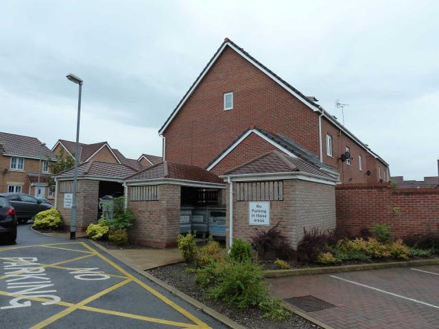 By CJO  ©tigger4242 |
![]() 19th May 2023 18:54 by RAH
19th May 2023 18:54 by RAH
Gridref: SD 56292 21179 FB Number: Not logged Condition: Destroyed Score: 5/10
![]() 12th Nov 2021 13:30 by Mickandkim
12th Nov 2021 13:30 by Mickandkim
Gridref: SD 56200 21100 FB Number: Not logged Condition: Destroyed Score: 1/10
Gone
![]() 24th Jun 2019 10:25 by RAH
24th Jun 2019 10:25 by RAH
FB Number: Not logged Condition: Destroyed Score: 0/10
This was part of the site occupied by the Chorley Royal Ordnance Factory. The land was cleared in the mid 1990s for housing.
![]() 17th Sep 2018 19:48 by Ant1974
17th Sep 2018 19:48 by Ant1974
FB Number: Not logged Condition: Destroyed Score: 5/10
![]() 2nd Jun 2018 12:55 by ted
2nd Jun 2018 12:55 by ted
FB Number: Not logged Condition: Destroyed Score: 0/10
Unclear what the Operations Centre was used for in its day. The site is now a large estate of uniform housing.
![]() 11th Mar 2018 14:45 by dugswell2
11th Mar 2018 14:45 by dugswell2
FB Number: Not logged Condition: Destroyed Score: 4/10
Long gone to housing.
![]() 12th Jan 2015 16:05 by rupertal
12th Jan 2015 16:05 by rupertal
FB Number: Not logged Condition: Destroyed Score: 2/10
![]() 19th Jul 2014 12:52 by CJO
19th Jul 2014 12:52 by CJO
FB Number: Not logged Condition: Destroyed Score: 5/10
Now a bin store on Anderson Crescent.
![]() 11th May 2014 13:57 by lonesome_cowboy_burt
11th May 2014 13:57 by lonesome_cowboy_burt
FB Number: Not logged Condition: Destroyed Score: 1/10
Housing
![]() 13th Apr 2014 19:03 by PeteBoggs
13th Apr 2014 19:03 by PeteBoggs
FB Number: Not logged Condition: Destroyed Score: 1/10
Just houses
![]() 24th Mar 2014 14:39 by tigger4242
24th Mar 2014 14:39 by tigger4242
Gridref: SD 56292 21179 FB Number: Not logged Condition: Destroyed Score: 5/10
Bolt and Centre gone. Now new housing on the GR.
![]() ©tigger4242
©tigger4242
![[map]](/img/trig-map.png.php?t=14740&b=2&l=0&)