![[UK map]](/img/locationmap.png)
| OSGB36 trig archive spreadsheet - IW | |||||||||||||
|---|---|---|---|---|---|---|---|---|---|---|---|---|---|
| Trig Name | Original Name | New Name | EASTING | NORTHING | HEIGHT | ORDER | TYPE OF MARK | Computing Date | CLASS OF LEVELLING | Date of Levelling | LEVELLING DATUM | DESTROYED MARK INDICATOR | COMMENTS |
| Stot Hill | NO89/27 | NO89S027 | 359221.32 | 803167.97 | 281.635 | 2 | PILLAR | 01/06/1950 | 2 | 01/06/1950 | N | 0 |
Nearby trigpoints, placenames
There are 14 photos for this trigpoint (view album).
This trigpoint:
Is ranked joint 4583rd with 77 other trigs (more).
Has a mean score of 5.76/10 (from 17 logged visits)
Was First logged: 6th Aug 2002
Was Last logged: 18th Apr 2024
Of the 17 logged visits,
5 recorded a location and of these....
All were within 10m
The average error was 6m
The closest was 1m
You are not logged in. You must login if you wish to log a visit.
Selection of photos for this Pillar. ©COVID Trig Point Challenge 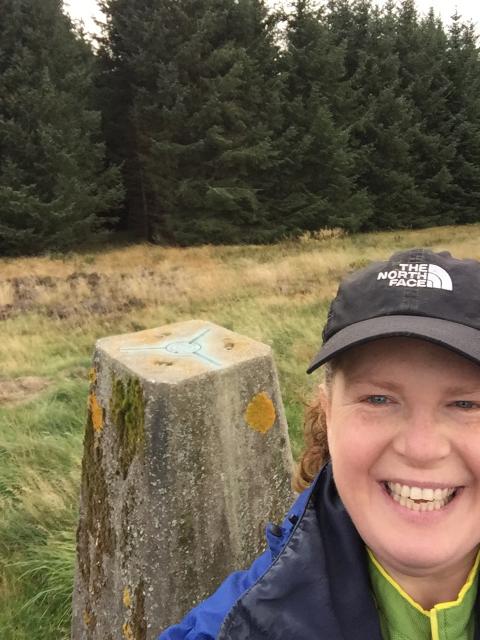 ©thejackrustles  By thejackrustles 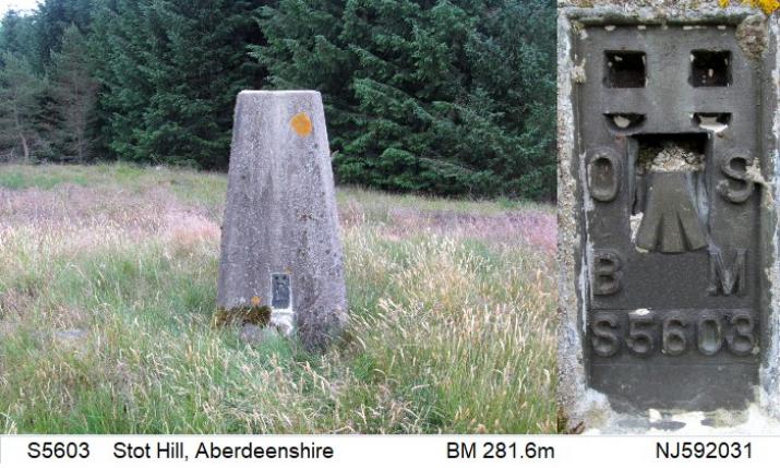 By clochandighter  By Sandrax2  By iainmac 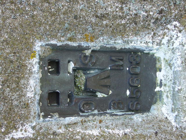 By iainmac See 7 more in the album. |
![]() 18th Apr 2024 14:40 by RoccosAdventures
18th Apr 2024 14:40 by RoccosAdventures
FB Number: S5603 Condition: Good Score: 8/10
Parked in centre of Torphins and walked out - a wee bit pesky but generally easy enough although through mixed terrain - interesting fortification before you get to the trig no views as such as surrounded by tress etc.
![]() 16th Jun 2023 16:21 by vegibagger
16th Jun 2023 16:21 by vegibagger
FB Number: S5603 Condition: Good Score: 5/10
16:39 aborted attempt by the 'easy ride' track used by others in the past from the north, by horrendous wind felled jungle at 240 metres up... Despite initial attempts left and right B4 abandoning. Back to car. New route along track eastwards then diagonally across fields up goence line ride the another ride left, south direct to the summit Trig S5603 deep indented lettering in OS cap
![]() 30th Jan 2023 11:31 by bobvictor67
30th Jan 2023 11:31 by bobvictor67
FB Number: Not logged Condition: Good Score: 5/10
![]() 11th Aug 2021 00:00 by caroleengel
11th Aug 2021 00:00 by caroleengel
Gridref: NJ 59221 03159 FB Number: Not logged Condition: Good Score: 5/10
Gate NJ 5948 0397 (parking lay-by to NW). Good wide break up thru' trees. At fence line- south, some long grass, old trees and a low fence, after which deer trod up break - easy
![]() 10th May 2021 14:57 by BigJ
10th May 2021 14:57 by BigJ
Gridref: NJ 59224 03162 FB Number: S5603 Condition: Good Score: 6/10
Followed the jackrustles route from the north and arrived at the pillar without incident. Strange that the top is devoid of trees. Site of a fort perhaps? With Nozzer.
![]() 10th May 2021 14:56 by nozzer
10th May 2021 14:56 by nozzer
Gridref: NJ 59221 03167 FB Number: S5603 Condition: Good Score: 6/10
![]() 9th May 2020 16:45 by benjaminrees
9th May 2020 16:45 by benjaminrees
FB Number: Not logged Condition: Good Score: 5/10
Found it mostly by chance when exploring clearings in the woods. Google maps satellite view reasonably helpful.
![]() 2nd May 2020 18:00 by andrewmcmurtrie
2nd May 2020 18:00 by andrewmcmurtrie
FB Number: Not logged Condition: Good Score: 6/10
![]() 20th Apr 2020 18:38 by COVID Trig Point Challenge
20th Apr 2020 18:38 by COVID Trig Point Challenge
FB Number: Not logged Condition: Good Score: 6/10
Trees obscuring most views.
![]() Steve Helmore ©COVID Trig Point Challenge
Steve Helmore ©COVID Trig Point Challenge
![]() 21st Sep 2018 14:33 by thejackrustles
21st Sep 2018 14:33 by thejackrustles
FB Number: S5603 Condition: Good Score: 7/10
1:25k essential for this. Parked in lay-by NJ 59472 03966 then up the very busy road to the gate NJ 59563 03902, followed mapped track to O2 mast NJ 59451 03740 and then crossed the fence at NJ 59292 03424 and took various firebreaks up to the trigpoint itself. Also walked onto the Cairn Mude, the track between the trig and the cairn was much rougher than expected. Back via same route.
![]() Stot Hill selfie ©thejackrustles
Stot Hill selfie ©thejackrustles![]() Stot Hill collage
Stot Hill collage
![]() 23rd Jun 2018 16:37 by coinea
23rd Jun 2018 16:37 by coinea
Gridref: NJ 59221 03160 FB Number: S5603 Condition: Good Score: 6/10
![]() S5603 Stot Hill ©coinea
S5603 Stot Hill ©coinea
![]() 23rd Jun 2018 16:36 by clochandighter
23rd Jun 2018 16:36 by clochandighter
Gridref: NJ 59220 03158 FB Number: S5603 Condition: Good Score: 7/10
Revisit. SITE VISIT: Overall approach from NNE. Parked in layby on NE side of A980 at NJ594039. Entered track continuing up mapped firebreak past comms mast which is still a track to NJ593034, then turning SE for ~100m, 1:25K map essential. Continued SSW via mapped firebreak until reaching top, making mental notes by looking behind upon leaving firebreaks for the return journey. Pillar in summit clearing. Column in good condition. Spider retains OS centre cap with deep indented letters. Flush bracket faces NNW, compass measurement 339°. Vented through NE sight hole. The view was lost to the surrounding woods many years ago.
![]() S5603 - Stot Hill & self
S5603 - Stot Hill & self![]() S5603 - Stot Hill pillar & FB
S5603 - Stot Hill pillar & FB
![]() 7th Feb 2018 14:07 by Sandrax2
7th Feb 2018 14:07 by Sandrax2
FB Number: S5603 Condition: Good Score: 7/10
![]()
![]()
![]() 12th Apr 2015 16:03 by Bexen
12th Apr 2015 16:03 by Bexen
FB Number: S5603 Condition: Good Score: 4/10
Fairly easy to get to trig as long as you have a 1:25000 map. If the tree's weren't there then the view would be really good.
![]() Trig and Flush Bracket ©Bexen
Trig and Flush Bracket ©Bexen
![]() 14th Jan 2009 12:00 by iainmac
14th Jan 2009 12:00 by iainmac
FB Number: S5603 Condition: Good Score: 3/10
1:25000 very useful here - easy fire breaks as shown up to the trig.
![]() 5th May 2007 12:00 by peregrinus
5th May 2007 12:00 by peregrinus
FB Number: S5603 Condition: Good Score: 4/10
vgc, metal cap, deep letters, largeish heather clearing. Lots of fun with this one - plantation much larger than on my map, which I'd left in the car, carrying just a compass and a rough idea of topography. Barns at NJ597035 also not on my map.
![]() 6th Aug 2002 12:12 by clochandighter
6th Aug 2002 12:12 by clochandighter
FB Number: S5603 Condition: Good Score: 8/10
HISTORY: Pillar completed 16th July 1949 costing £10.17s.6d. Computed as secondary triangulation station NO89/27 with the Aberdeen block during 1950. Levelled for height also in 1950. Last maintained by the OS in July 1978. SITE VISIT: Stot Hill was approached from the east, probably the only semi-reasonable approach. Trig pillar in good condition. Spider retains OS centre cap with stamped lettering. Flush bracket faces north. Decending west or north from the summit seemed impossible due to the undergrowth and dense woods. I decended southwards through a fire break fighting deep ferns, weeds and channelled bogs so cannot recommend that route either.
![]() S5603 - Stot Hill pillar & FB
S5603 - Stot Hill pillar & FB
![[map]](/img/trig-map.png.php?t=6215&b=2&l=0&)